Since 2008, the Chilean Ministry of the Environment (MMA) started the Noise Maps program for cities in Chile. In 2011 the first version of the Noise Map of Greater Santiago was made, and during 2016, this Noise Map was updated, being published and available for general public.
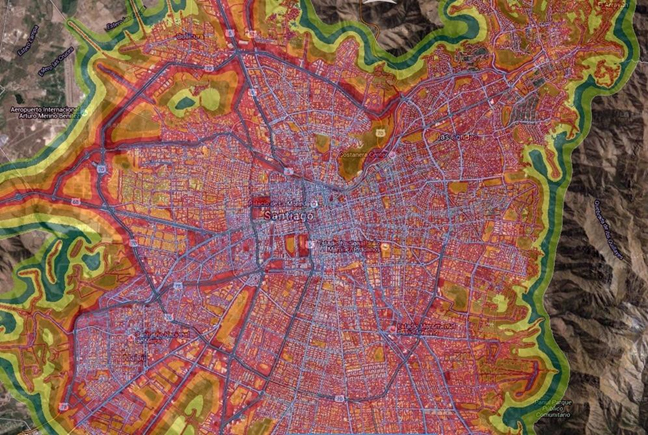
Santiago de Chile Noise Map as of 2016
What is a noise map?
A noise map is an environmental management tool that makes it possible to identify the noise levels present in a city. There are several ways to develop a noise map, the most common is by predicting noise levels, using urban variables and information on land and transport traffic. A Noise Map is a mathematical model and a function of Transit flow and City Shapes. Traffic noise is considered the main source of environmental noise in a city. Traffic can be terrestrial, aerial and or maritime.
A noise map is useful because it helps to
- Identify places with higher or lower level of environmental noise
- Diagnose and quantify populations exposed to environmental noise problems.
- Design environmental noise control measures
- Evaluate the effectiveness of the environmental noise control measures.
- Disseminate the problem of environmental noise to the public.
- Promote public policies for the management of environmental noise.
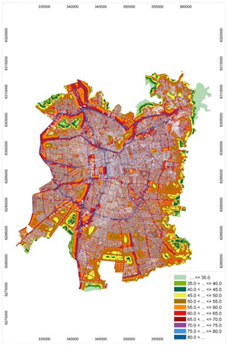
Although noise maps are calculated based on vehicular traffic -wich is also measured-, it is necessary to carry out many measurements in different spots around the city. It is not enough to measure a few minutes, it is necessary to measure at least one continuous week, and thus have a day / night profile and business days and holidays noise behaviour. These data sets are then used to verify the fitness of predictive models selected by the scientists in charge. In this project, the entity in charge of implementing and carrying out the measurements was the Acoustics Institute of the Universidad Austral de Chile.
Why and how to use NSRT128 for Noise Mapping ?
Fort Greater Santiago Noise Map, a total of 8 Convergence Instrument´s NSRT128, were mounted on light poles around the city at diferent kind of avenues (looking for relevant vehicle flow rate, speed, street width, among other relevant parameters). Each NSRT128 was left for a week at each point, to get data needed for the noise map modeling process. These measurements where complemented by spot measures made with hand held sound level pressure meters from other diverse brands.
NSRT128 was right for the job for two reasons: its smart sound level meters, which feature small size, enough power for a week of unattended measurement, highly accurate SPL data logging capabilities; and local support and assistance through local representative Vitglobal.com Instrumentation Services wich was always on duty to support field engineers during the measurement campaign.
Cast to the Community
Finally, the map is announced and published Online for the public, mounted as an extra layer on some mapping/gis websites, and used by authority to feed their plans for city pollution managment.
Noise Sentry has been used in some other Maps, like City of Coronel in Chile, and today is the most used Noise Datalogger in Chile, where Universities, authority and many consultant firms rely on Convergence Instruments solutions for their noise datalogging needs.
Links